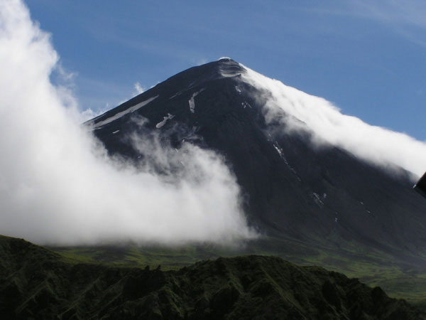
At current (Aug 01, 2011), the Alaska Volcano Observatory’s website status report has an advisory listed for Mount Cleveland:
“A weak thermal anomaly was observed in satellite images of Cleveland over the past day… Short-lived explosions with ash clouds that could exceed 20,000 ft above sea level can occur without warning and may go undetected on satellite imagery for hours. Low-level ash emissions at Cleveland occur frequently and do not necessarily mean a larger eruption is imminent. AVO continues to monitor the volcano using satellite imagery.”
Calculating risk
Mt. Cleveland, while frequently unrestful, is remote from population centers and rarely interferes with high-flying aircraft. AVO Volcanologist Game McGimsey notes that the Observatory does “Not have a seismic network on the island,” and “Must rely on satellite remote sensing and the occasional pilot or mariner report for keeping tabs on activity.” Still worse, there is a “Propensity for the volcano to be obscured by clouds,” making Cleveland “A continuous thorn under AVO’s saddle.”
Volcanologist Game McGimsey is FrontierScientists’ current Scientist on Call. For a limited time, you can email him your volcano-related questions from the FrontierScientists front page [Ask Me!] button.
Volcanologists, like those at the United States Geological Survey – Alaska Volcano Observatory (USGS-AVO) in Anchorage and other Volcano Observatories, face the daunting responsibility of forecasting eruptions and forewarning communities at risk, including local residents and area air-travel. The U.S. Geological Survey’s Volcano Disaster Assistance Program (VDAP) even has a team which helps respond to volcano emergencies abroad.
To meet these goals scientists utilize a wide array of tools and sensors in their work. Sensors can help detect and measure early-warning signs of impending eruptions. Seismometers are employed to measure earthquake activity. Global Positioning System monitors can help detect surface deformation, while ‘Tiltmeters’ measure slope angle, and Electronic Distance Meters measure the distance between sites placed on the flanks of a volcano to detect underground magma uprisings. All of the information gathered adds to the database of knowledge about volcanic activity, and will assist in understanding future signs of imminent eruption and in anticipating the rate and styles of eruption.
The power of the human eye
Visual data examined by the human eye is also an effective tool in understanding volcano activity. Scientist Kam Lulla, of the Human Exploration Science Office at NASA’s Johnson Space Center, says: “Humans are smart, trainable sensors.” Those at NASA know that the human eye is an underrated instrument. Volcanologists who gain visuals of volcanic unrest learn a lot. Local visits, webcam video, temperature maps, and high-resolution photos from satellites all prove priceless… and visually enchanting.
Underwater volcanoes
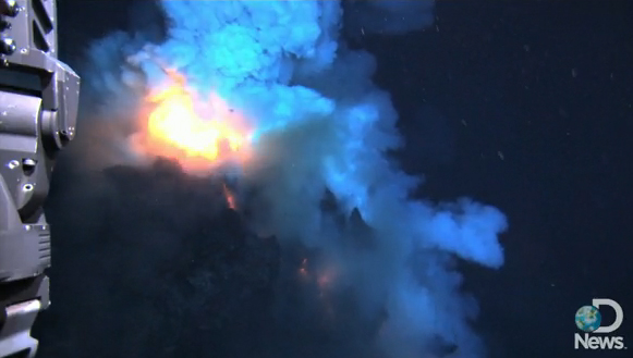
Deep under the sea, nearly 4,000 feet under the waves of the Pacific Ocean, lies the West Mata Volcano. There are a staggering number of deep-sea volcanoes, but because they are so difficult to reach, few are well-understood. In December of 2009 a mission funded by the National Oceanic and Atmospheric Administration and the National Science Foundation and led by chief scientist Joseph Resing recorded the West Mata Volcano erupting. The team used ‘Jason’, a Woods Hole Oceanographic Institution remotely-operated underwater robot, to record the groundbreaking shots. Watch the Discovery News story here: [http://www.youtube.com/watch?v=hmMlspNoZMs]
Resing states that “Eighty percent of the eruptions, basically, on Earth, are happening underwater,” yet “Strangely enough, we really have never seen molten lava flowing on the sea floor from a submarine volcano.” Since the West Mata Volcano is placed so deep below the ocean’s surface, its eruptive style is close to the style of the eruptions which formed most of the oceanic crust. Obtaining the video grants volcanologists a chance to better understand how magma reacts at places where one tectonic plate is subducted under a neighboring plate, as well as more data concerning oceanic carbon dioxide and sulfur gas cycles, and how life-forms (namely diverse microbes) adapt to the acidic conditions caused by undersea eruptions
Rising from the depths, the volcanoes of Hawaii prove a persistent challenge to monitors. Because the active volcanic islands support human populations, volcanic hazards prove even more dire and require especial preparedness through response plans and mitigation measures. Hazards include lava flows, land- and mud- slides, pyroclastic flows and volcanic ash or tephra, air pollution and gases that provide health risks, among others. Accordingly, the Hawaiian Volcano Observatory scientists analyze signs of precursory unrest carefully. They utilize a number of camera systems, which record truly beautiful shots. Here, watch one of their time lapse movies from the flank of volcano Pu`u `O`o. The video records fountaining from the Martin Luther King Vent in February 2005. The highest fountain reached about 10 meters into the air. [http://hvo.wr.usgs.gov/gallery/kilauea/volcanomovies/movies/MLK%20fountain%20-%20Feb%209-10,%202005-small.mov]
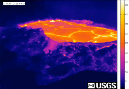
There are other amazing images at the Hawaiian Volcano Observatory’s website, including this one, taken with a thermal camera set on the Pu`u `Ō `ō crater rim and showing July 2011 activity: an uplift of the lava lake and crater floor.
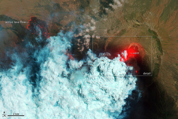
NASA has a fine history of taking photographs of the Earth from space, photos which benefit the scientific community. Their ‘Gateway to Astronaut Photography of Earth – Mission Highlights’ website contains a library of stunning pictures. It states that “Astronauts have used handheld cameras to photograph the Earth since the Mercury missions in the early 1960s, taking more than 800,000 photographs of Earth.” Volcanologists can study these astronaut- and satellite- obtained images. FrontierScientists Volcano From Space video documents one example of cooperation between NASA and AVO geologists. And, more recently, here is a colored photo of Eritrea’s Nabro volcano erupting, June 2011.
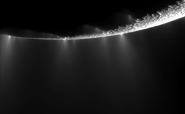
Finally, let’s look far out – to space. The largest volcano in the solar system is on Mars: the colossal Olympus Mons. Venus’ volcanoes are more plentiful than any other of our system’s planets. The website Astromind lists ‘Eruptions of Volcanoes in Solar System’ on: Jupiter’s Moon Io, Neptune’s moon Triton, Enceladus, Jupiter moons Ganymede and Europa, and Saturn’s moon Titan. With increasingly impressive equipment and eternal human curiosity, who knows what we’ll see next.
Laura Nielsen
Frontier Scientists: presenting scientific discovery in the Arctic and beyond
Cook Inlet Volcanoes project
- ‘Eruptions of Volcanoes in Solar System’ Astromind
http://www.astronomind.com/eruptions-of-volcanoes-in-solar-system - ‘The Gateway to Astronaut Photography of Earth’ Image Science and Analysis Laboratory, NASA-Johnson Space Center
http://eol.jsc.nasa.gov/debrief/ISS028/top1.htm - ‘Kilauea Volcano : Time Lapse Movies’ U.S. Geological Survey – Hawaiian Volcano Observatory site
http://hvo.wr.usgs.gov/gallery/kilauea/volcanomovies - ‘Remote Nabro Volcano Eruption Revealed in Satellite Photos’ Space.com
http://www.space.com/12109-nabro-volcano-eruption-eritrea.html - ‘Scientists Discover and Image Explosive Deep-Ocean Volcano’ National Oceanic and Atmospheric Administration
http://www.noaanews.noaa.gov/stories2009/20091217_volcano2.html
